
Flood Risk Tools for New Jersey and New York Communities
Besides the updated Flood Insurance Rate Maps (FIRMs) and Flood Insurance Study (FIS) reports being developed based on the coastal flood study underway, FEMA, in partnership with the New Jersey Department of Environmental Protection and other organizations, is also providing communities with other tools they can use to better understand and plan for flood risk.
What Are Flood Risk Tools and How Can They Be Used?
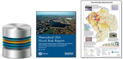
Flood risk tools can help community officials in planning efforts to reduce (or “mitigate”) flood risk, communicate with the public, and create a dialogue with neighboring communities about ways to reduce future flood risk. There are different types of flood risk tools (also referred to as “non-regulatory products”), including GIS datasets, maps, and reports. Each is described on the Flood Risk Tools Descriptions page. These tools are not directly tied to regulatory development standards and insurance requirements of the National Flood Insurance Program like the FIRM and FIS report are but are nonetheless important resources to support community planning efforts.
When Will the Flood Risk Tools Be Released?
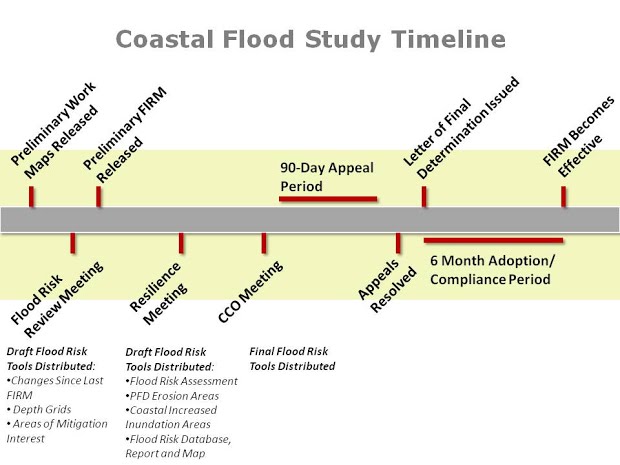
The flood risk tools are in the process of being released on a rolling basis by county. Draft versions of certain tools will initially be released at the time of Flood Risk Review and Flood Resilience meetings for each community. Final versions of the tools will be released at the time of the CCO meeting. (See graphic below).
Where Can I Get the Flood Risk Tools?
Flood risk tools are currently being developed and will be available through county-specific links below as they are released. Draft versions of certain flood risk tools are now available for the counties listed below:
- Atlantic County*
- Bergen County
- Camden County
- Cape May County*
- Essex County
- Gloucester County
- Hudson County
- Ocean County
- Middlesex County
- Monmouth County
- Union County
- Westchester County, NY
Datasets Available: Changes Since Last FIRM, Flood Depth and Water Surface Elevation Change Grids, Areas of Mitigation Interest, and for selected counties Coastal Flood Risk Assessments and Coastal Increased Inundation Areas (Visit the Flood Risk Tools Descriptions page for descriptions of these datasets)
* In these counties, a dataset which shows the change between the flood hazards shown on the Advisory Base Flood Elevation (ABFE) maps and the preliminary work maps which show the full results of the coastal flood study is available.
Please be advised that all datasets available through the links above are currently in draft form and are subject to change.
How Can I Learn More About the Flood Risk Tools?
Visit the Flood Risk Tools Descriptions page to learn more about each dataset and product which will be distributed. Additionally, the documents below provide more information about the flood risk tools and how they can be used.