
Understanding Vertical Datums: Frequently Asked Questions
The Federal Emergency Management Agency (FEMA) is committed to continuing the recovery process in New Jersey and New York by providing the best assessment of flood risk to help guide communities in their efforts to reduce the impact of flood events and protect lives and property from future damages. To accomplish this, FEMA has released updated flood hazard data for certain coastal communities in New Jersey and New York affected by Hurricane Sandy, in the form of Advisory Base Flood Elevation (ABFE) maps, preliminary work maps, and preliminary Flood Insurance Rate Maps (FIRMs). Learn more about how FEMA recommends this information be used on the Using FEMA Flood Hazard Data page.
The elevations shown on the ABFE maps, preliminary work maps and preliminary FIRMs released by FEMA are referenced to the North American Vertical Datum of 1988 (NAVD88). Here’s a look at what vertical datums are and how to use them with the updated maps, in question and answer format.
If you have additional questions regarding vertical datums not answered on this page or require additional assistance, please call the National Flood Insurance Program Help Center at 1(800) 427-4661 or contact the FEMA Map Information eXchange.
What is a Vertical Datum?
A vertical datum is a base measurement point (or set of points) from which elevations are determined. Historically, the standard datum used by the federal government was the National Geodetic Vertical Datum of 1929 (NGVD 29). However, the North American Vertical Datum of 1988 (NAVD 88) is now the national standard. There are also many other different vertical datums available. For example, local vertical datums have been established for each of the five boroughs of New York City:
• Bronx Datum;
• Brooklyn Datum;
• Manhattan Datum;
• Queens Datum; and
• Richmond Datum.
Why are there so many vertical datums?
Over the years, different datums have been established based on the technology and information on hand and the need for a vertical reference point in a given area. The use of Global Position Systems (GPS) satellites to measure elevations and observations from coastal gages have helped government agencies develop new, more accurate datums, such as NAVD 88, which allow for the better comparison of elevations.
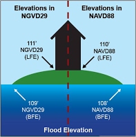
Why does it matter which vertical datum an elevation is referenced to?
Elevation values based on different vertical datums cannot be used together directly since they are based on a different vertical reference point (See graphic below). When comparing the updated flood hazard data released by FEMA with elevation information on Elevation Certificates and other documents from different sources, care must be taken to ensure all elevations are in the same datum. If they are not the same, a conversion factor must be applied so that the values are referenced to the same datum before they are used. Failure to do so can result in improper structure design (e.g., building at the wrong elevation) which can have serious implications in terms of complying with community and state building requirements. Flood insurance rates can also be impacted.
Why is FEMA using NAVD88 for the updated maps?
NAVD88 is more compatible with modern surveying and mapping technologies like Global Positioning Systems (GPS). It also is more accurate than the previous national vertical datum, NGVD29.
What do I do if I have elevation information for my house but the information is not in the NAVD88 datum?
When you have elevations referenced to different datums, you will need to apply a conversion factor in order to properly compare the two. The conversion factor needed will depend on the original datum an elevation is referenced to, and the datum you are converting the elevation to.
Is there a table of conversion factors for the various New York City datums available?
Yes. Please see the table below.
New York City Datum Conversion Table
Find the datum conversion factor value in the table below by locating the current datum of your elevation data in the top row and the datum you’d like to convert to in the left column. Then find the conversion factor value at the intersection of those fields.
|
Table Usage Instructions: Step 1: Find the datum your elevations are currently referenced to in the row to the right. Step 2: Find the datum you would like to convert your elevations to in the column below. Step 3: At the intersection of those fields, you will find the conversion factor needed to convert your elevations. |
NAVD88 Datum |
NGVD29 Datum |
Bronx Datum |
Brooklyn Datum |
Manhattan Datum |
Queens Datum |
Richmond Datum |
| NAVD88 Datum | N/A | -1.1 feet | +1.508 feet | +1.447 feet | +1.652 feet | +1.625 feet | +2.092 feet |
| NGVD29 Datum | +1.1 ft | N/A | +2.608 feet | +2.547 feet | +2.752 feet | +2.725 feet | +3.192 feet |
| Bronx Datum | -1.508 feet | -2.608 feet | |||||
| Brooklyn Datum | -1.447 feet | -2.547 feet | |||||
| Manhattan Datum | -1.652 feet | -2.752 feet | |||||
| Queens Datum | -1.625 feet | -2.725 feet | |||||
| Richmond Datum | -2.092 feet | -3.192 feet |
How does one use the New York City datum conversion table?
As an example, using the table above, if you have a first floor elevation of 6.0 ft (Richmond Datum) for a property in Staten Island (Richmond County) then the elevation in NAVD88 would be: 6.0 ft + 2.092 feet = 8.092 ft. Similarly, if you had an elevation of 8.0 feet (NAVD88) for the same property in Staten Island the elevation in the Richmond Datum would be: 8.0 ft – 2.092 ft = 5.908 feet.
Is there a table of conversion factors available to compare updated FEMA flood hazard data with the effective FIRMs in New Jersey?
In New Jersey, conversion factors (please see table below) are needed only for Atlantic, Bergen, Burlington, Cape May, Salem, Cumberland, and Union Counties in New Jersey as the effective Base Flood Elevations (BFEs) shown on these FIRMs are in NGVD29. For other counties in New Jersey affected by the coastal flood study, the effective BFEs shown on the FIRMs are in NAVD88. Thus no conversion factor is needed to compare the updated flood hazard data released by FEMA and the effective FIRMs for those counties.
I have elevation data in datum NGVD29 for:
|
Atlantic Co. |
Bergen Co. |
Burlington Co. |
Cape May Co. |
Union Co. |
Salem Co. |
Cumberland Co. |
|
| I want elevations in NAVD88 | -1.2 feet | -1.0 feet | -1.3 feet | -1.3 feet | -1.0 feet | -1.0 feet | -1.1 feet |
OR
I have elevation data in datum NAVD88 for:
|
Atlantic Co. |
Bergen Co. |
Burlington Co. |
Cape May Co. |
Union Co. |
Salem Co. |
Cumberland Co. |
|
| I want elevations in NGVD29 | +1.2 feet | +1.0 feet | +1.3 feet | +1.3 feet | +1.0 feet | +1.0 feet | +1.1 feet |
Is there a table of conversion factors for other areas of New Jersey available?
Information about datum conversions for Middlesex, Monmouth, Hudson and Ocean Counties is provided in the table below. Please be advised that no conversion factor is needed to compare the updated flood hazard data released by FEMA and the effective FIRMs for these counties since both are referenced to NAVD88. However, elevations contained in other maps and documents may reference NGVD29 and require conversion.
I have elevation data in datum NGVD29 for:
|
Middlesex Co. |
Monmouth Co. |
Hudson Co. |
Ocean Co. |
|
| I want elevations in NAVD88 | -1.1 feet | -1.1 feet | -1.1 feet | -1.2 feet |
OR
I have elevation data in datum NAVD88 for:
|
Middlesex Co. |
Monmouth Co. |
Hudson Co. |
Ocean Co. |
|
| I want elevations in NGVD29 | +1.1 feet | +1.1 feet | +1.1 feet | +1.2 feet |
How does one use the New Jersey datum conversion tables?
As an example, using the table above for a location in Burlington County, if you have a first floor elevation of 6.0 ft (NGVD29) for a property, then the elevation in NAVD88 would be: 6.0 feet – 1.3 feet = 4.7 feet. Similarly, if you had an updated elevation of 3.0 ft (NAVD88) for the same property in Burlington County, the elevation in NGVD29 would be: 3.0 feet + 1.3 feet = 4.3 feet.
Are there any tools on the web to help convert between datums?
Yes, the National Geodetic Survey has developed a tool for advanced users to convert between NGVD29 and NAVD88. This tool, called VERTCON, can be found at http://www.ngs.noaa.gov/cgi-bin/VERTCON/vert_con.prl.
How does one use the VERTCON datum conversion tool?
The National Geodetic Survey provides an online tool to help users convert between the datums for any location. A step-by-step guide is provided below.
1) Access the datum conversion online tool at http://www.ngs.noaa.gov/cgi-bin/VERTCON/vert_con.prl.
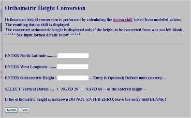
2) Enter the North Latitude and West Longitude positions. List both positions as positive numbers. Positions may be entered in any of the following three formats:
• degrees, minutes and decimal seconds ( xxx xx xx.xxx)
• degrees and decimal minutes ( xxx xx.xxx)
• decimal degrees ( xxx.xxxxx)
Note: There MUST be one or more blanks between entry fields. Decimals can be keyed commensurate with the field’s precision, but are not required.
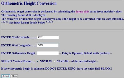
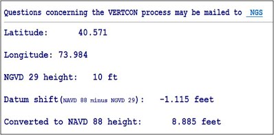
3) Enter the height to convert. Note: The default unit is meters. Enter “ft” after the number to show the elevations and conversion factor in feet.
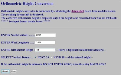
4) Select the vertical datum of the height entered (i.e., this example is converting 10 ft NGVD29 into NAVD88; therefore, NGVD29 was chosen).
5) Click Submit. The result reveals both the conversion factor (-1.115 ft in this example) and the what the original elevation height is once converted to the new datum (8.885 ft NAVD88 in this example).
Where can I find more information about vertical datums?
If additional details are needed, the following resources may be helpful.
• For FEMA’s guidelines regarding vertical datum conversions, visit:
Vertical Datum Conversion Guidance and click on Appendix B.
• Additional information on vertical datums, including the conversion from NGVD29 to NAVD88 at any location, can be found by visiting the National Geodetic Survey website.