
Guidance for Communities in Using FEMA’s Flood Hazard Data
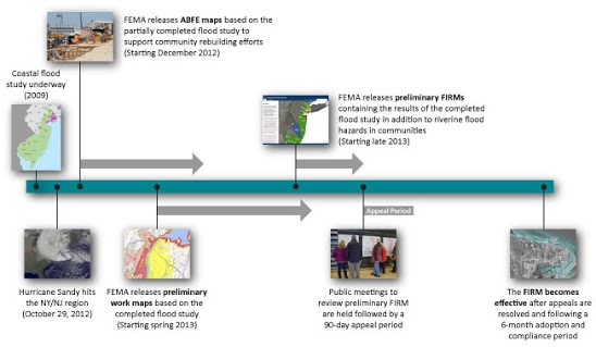
FEMA Flood Hazard Data Release for Coastal NJ/NY (Click to enlarge)
The National Flood Insurance Program (NFIP) regulations do not require communities to use the flood hazard information from the preliminary Flood Insurance Rate Maps (FIRMs) (or other products such as preliminary work maps or Advisory Base Flood Elevation [ABFE] maps) instead of flood hazard information from an effective FIRM to regulate development. However, for Zone A areas where no Base Flood Elevation (BFE) has been identified on the effective FIRM, Section 44 CFR 60.3(b)(4) of the NFIP regulations does require communities to reasonably use BFE and floodway data from a Federal, State, or other source. Learn more in FEMA’s Floodplain Management Bulletin 1-98 Use of Flood Insurance Study Data as Available Data (FPM 1-98).
While the use of flood hazard information in draft or preliminary form may not be an NFIP requirement, the State of New Jersey is using this information as the basis for statewide floodplain development standards. New York City has adopted similar requirements.
FEMA Flood Hazard Resources
Once released, the preliminary FIRMs will be the most recent flood hazard information available from FEMA, replacing preliminary work maps and ABFE maps previously issued in the region. If your community uses the preliminary FIRMs (or other draft FEMA flood data) as the basis of development decisions, it must always compare this information to the effective FIRM for a given development site and use the most restrictive of the two. Also keep in mind that State requirements may be more restrictive. Communities that decide to use the more recent FEMA flood hazard information should adopt the information into its floodplain management ordinances.
Information about the use of FEMA map products for federally funded rebuilding undertaken as part of the Sandy recovery is available through the FEMA Procedure Memo dated April 30, 2013, Revised Guidance for Use of Best Available Data to Implement Federal Flood Risk Reduction Standards for Areas Impacted by Hurricane Sandy. The Best Available Data Archive page is a running data archive of changes to flood hazard data in the region, including all releases of ABFE, preliminary work map, and preliminary FIRM information as they occur.
Questions or comments? Call the National Flood Insurance Program Help Center at 1-800-427-4661 or visit our Contacts page to find a subject matter expert who can help.